

 How to survive a power outage in winte
 Monarch Butterflies That Should Have Migrated South Have Yet to Leave Canada
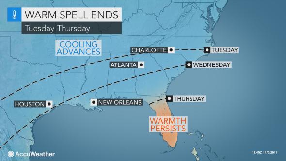 Rain, cooler air to sweep record-challenging warmth out of southern US this week
 Franken-Philippe Bringing Damaging Winds
 Exploring Solar Storms
 Tropical Storm Philippe Drenches Florida and Cuba
 Hole in the ozone layer over Antarctica
 The history of the barometer
Franken-Philippe Bringing Damaging Winds
Tropical Storm Philippe is no more, done in on Sunday afternoon by over 50 knots of wind shear and merger with a cold front near the North Carolina coast. But much of the moisture and energy from the season’s 16th named storm will feed into a powerful non-tropical coastal storm gathering strength off the coast of North Carolina, and this new “Franken-Philippe” storm is poised to bring damaging high winds and flooding rains to the Northeast U.S. Sunday night though Monday.
 Figure 1. GOES-16 satellite image of Franken-Philippe at 4 pm EDT Sunday, October 29, 2017. Image credit: NOAA/RAMMB. GOES-16 data is considered preliminary and non-operational.
Outlook for Franken-Philippe
Early Sunday evening, Franken-Philippe was deepening rapidly at a rate of about 2 mb per hour, as the storm sped northwards towards New England. The center of the storm is expected to move over the New York City area at approximately midnight Sunday night, with a central pressure near 975 mb. As noted in our Saturday post, this pressure would make the storm the first or second strongest October storm of the past 30 years (behind Hurricane Sandy of 2012) in much of the region.
Given that Franken-Philippe is drawing in a rich stream of tropical moisture associated with the remains of Tropical Storm Philippe, a large portion of the Northeast could see more than 2 inches of rainfall, with some isolated amounts in excess of 5 inches. As of 6 pm EDT Sunday, New York City had already received 1.77” from the storm. The heaviest rainfall is expected in portions of Upstate New York and northern New Hampshire.
Franken-Philippe Rain
 Figure 2. Total 48-precipitation forecast for the period 2 am Sunday, October 29 – 2 am Tuesday, October 31, from the 2 am EDT Sunday, October 29, 2017 run of the NAM model. Rainfall amounts in excess of 2” (purple colors) were predicted over much of the Northeast U.S. Image credit: tropicaltidbits.com.
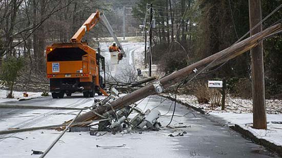
Much of coastal New England from Long Island, NY to northern Maine is likely to experience sustained tropical storm-force winds. Gusts to near hurricane strength are likely from Eastern Long Island to the coast of Southeast Massachusetts. Strong winds will move well inland, causing significant tree damage and power outages over much of New England, given that many trees are still leafed out in the wake of a near-record-warm autumn. Greg Carbin, chief of the forecast operations branch at NOAA/NWS Weather Prediction Center (and a Vermont native), called the impending storm a potential “leaf-stripping tempest.”